
Geography Masterclass: A Definitive Guide for All Exams
Welcome to the final revision guide you will ever need for Geography. This masterclass is meticulously crafted for the serious aspirant who seeks a single, comprehensive resource. It integrates the foundational principles of World Geography with an exhaustive, exam-oriented analysis of Indian Geography, covering everything from physical and human geography to environmental and economic aspects. Let's begin.
Master Index
- Part A: Foundational Physical Geography
- 1. Geomorphology: The Science of Landforms
- 2. Climatology: Understanding Our Climate
- 3. Oceanography: The Marine Realm
- 4. Biogeography & Environmental Geography
- Part B: Foundational Human & Economic Geography
- Part C: In-Depth Indian Geography (High-Yield Section)
- 7. India: Location, Frontiers & States
- 8. Physiography: Mountains, Plateaus, Plains (Detailed)
- 9. The River Systems of India (Detailed)
- 10. Climate of India: The Monsoon Deep Dive
- 11. Soils of India (Detailed)
- 12. Natural Vegetation & Forests (Detailed)
- 13. Agriculture: Crops & Revolutions
- 14. Mineral & Energy Resources (Detailed)
- Part D: The Winning Strategy
Part A: Foundational Physical Geography
1. Geomorphology: The Science of Landforms
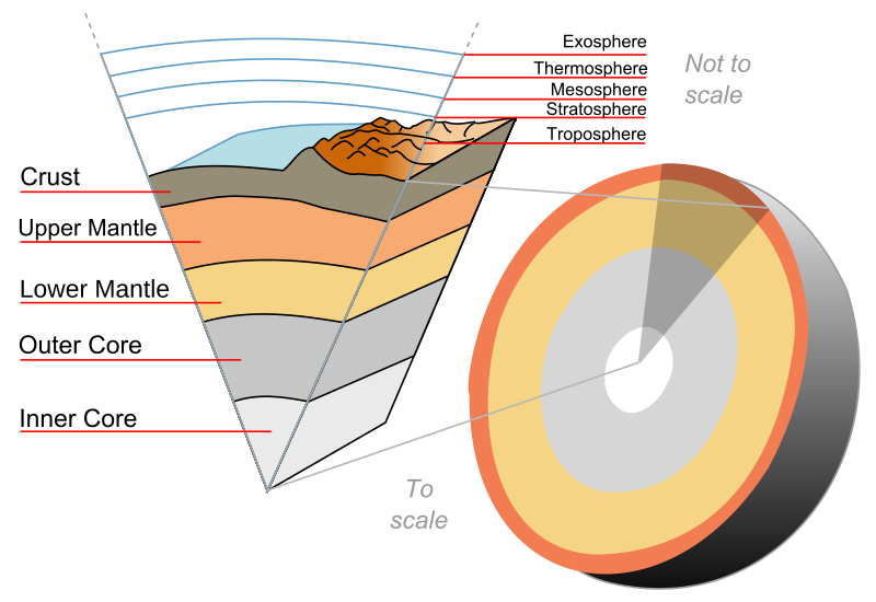
i. Earth's Interior & Structure
The Earth's interior is layered, understood through seismic wave studies. Key discontinuities are Mohorovičić Discontinuity (between Crust and Mantle) and Gutenberg Discontinuity (between Mantle and Core).
ii. Plate Tectonics & Continental Drift
Proposed by Alfred Wegener as Continental Drift and later refined into Plate Tectonics. The Lithosphere is broken into plates (e.g., Pacific, Eurasian, Indo-Australian) moving over the Asthenosphere.
iii. Rocks and the Rock Cycle
There are three major rock types constantly being transformed through the Rock Cycle.

- Igneous: Formed from magma/lava (Granite, Basalt).
- Sedimentary: Formed from sediment compaction (Sandstone, Limestone).
- Metamorphic: Altered by heat/pressure (Marble from Limestone, Slate from Shale).
iv. Landforms (Fluvial, Glacial, Aeolian)
Landforms are shaped by exogenic forces. Erosional Landforms are created by removing material (e.g., Valleys, Cirques), while Depositional Landforms are created by adding material (e.g., Deltas, Moraines, Sand Dunes).
2. Climatology: Understanding Our Climate
i. Composition and Structure of Atmosphere
Layers from ground up: Troposphere (all weather), Stratosphere (Ozone Layer, ideal for jets), Mesosphere, Thermosphere (contains Ionosphere for radio waves), Exosphere.
ii. Insolation, Heat Budget, and Global Winds
The Earth maintains a temperature balance through its Heat Budget. Uneven heating drives global wind patterns like Trade Winds, Westerlies, and Polar Easterlies.
iii. World Climate Zones (Köppen Classification)
A widely used system classifying world climate into groups like Tropical (A), Dry (B), Temperate (C), Continental (D), and Polar (E).
3. Oceanography: The Marine Realm
i. Ocean Floor Relief
Features include: Continental Shelf, Continental Slope, Abyssal Plain, and Oceanic Trenches (e.g., Mariana Trench, the deepest point on Earth).
ii. Ocean Currents
They act as global heat conveyors. Warm currents (Gulf Stream, Kuroshio) and Cold currents (Labrador, Canary) influence coastal climates. The mixing of warm and cold currents creates the world's best fishing grounds.
4. Biogeography & Environmental Geography
i. Ecosystems and Biomes
A Biome is a large community of vegetation and wildlife adapted to a specific climate. Major biomes: Tundra, Taiga, Temperate Grasslands (Prairies, Steppes), Deserts, Tropical Rainforests.
ii. Biodiversity, Conservation, and Environmental Issues
This field covers biodiversity hotspots, conservation methods (In-situ: National Parks, Biosphere Reserves; Ex-situ: Zoos, Gene Banks), and global issues like Climate Change, Ozone Depletion, and Deforestation. Key international conventions include the Ramsar Convention (wetlands), CITES (endangered species), and the Paris Agreement (climate).
Part B: Foundational Human & Economic Geography
5. Population & Settlement Geography
i. Population Dynamics
Key concepts include: Crude Birth Rate, Crude Death Rate, Migration, and Population Density. The Demographic Transition Model describes how a country's population changes over time as it develops.
ii. Human Settlements
Study of how and why people live where they do. Settlements are classified as Rural (villages, hamlets) and Urban (towns, cities, megalopolis). Patterns can be linear, circular, or dispersed.
6. Economic Geography & Regional Planning
i. Sectors of Economy
- Primary: Extraction of raw materials (Agriculture, Mining, Fishing).
- Secondary: Manufacturing and processing (Car factory, Steel mill).
- Tertiary: Service sector (Banking, Transport, Teaching).
- Quaternary: Knowledge-based, IT, R&D.
- Quinary: Top-level decision-making (CEOs, government officials).
ii. Regional Planning
The process of designing and regulating the use of land to improve a community's physical, economic, and social efficiency. It aims to reduce regional disparities and promote balanced development.
Part C: In-Depth Indian Geography (High-Yield Section)
7. India: Location, Frontiers & States
Latitudinal Extent: 8°4'N to 37°6'N | Longitudinal Extent: 68°7'E to 97°25'E
Tropic of Cancer (23.5°N) passes through 8 states: Gujarat, Rajasthan, MP, Chhattisgarh, Jharkhand, WB, Tripura, Mizoram.
Indian Standard Meridian (82°30'E) passes through 5 states: UP, MP, Chhattisgarh, Odisha, AP.
8. Physiography: Mountains, Plateaus, Plains (Detailed)

i. The Himalayas (Detailed)
Divided into 3 parallel ranges. Key peaks and passes are critical for exams.
| Range | Important Peaks | Important Passes |
|---|---|---|
| Himadri (Greater) | Kanchenjunga, Nanda Devi, Kamet | Zoji La (Srinagar-Leh), Shipki La (HP-Tibet) |
| Himachal (Lesser) | Ranges: Pir Panjal, Dhaula Dhar | Banihal Pass (Jawahar Tunnel) |
ii. The Peninsular Plateau (Detailed)
- Western Ghats (Sahyadris): Continuous range. Highest Peak: Anai Mudi (2695m) in the Annamalai Hills.
- Eastern Ghats: Discontinuous range. Highest Peak: Jindhagada Peak (1690m).
- Meeting Point: The Western and Eastern Ghats meet at the Nilgiri Hills.
9. The River Systems of India (Detailed)
The distinction between Himalayan and Peninsular rivers is crucial.

| River | Origin | Key Tributaries |
|---|---|---|
| Ganga | Gangotri Glacier | L-Bank: Ramganga, Ghaghara, Gandak, Kosi. R-Bank: Yamuna, Son. |
| Indus | Bokhar Chu Glacier (Tibet) | Jhelum, Chenab, Ravi, Beas, Satluj (Panchgnad). |
| Brahmaputra | Chemayungdung Glacier (Tibet) | Dibang, Lohit, Subansiri, Manas. |
| Godavari | Trimbakeshwar (Nashik) | Penganga, Wainganga, Wardha (together Pranhita), Indravati. |
| Krishna | Mahabaleshwar | Tungabhadra, Bhima, Koyna. |
| Narmada | Amarkantak Plateau | Flows west in a rift valley. Forms estuaries. |
10. Climate of India: The Monsoon Deep Dive
India's climate is influenced by the Monsoons, Jet Streams, and El Niño/La Niña (ENSO).
- South-West Monsoon: Driven by the intense low pressure over the Tibetan plateau and the northward shift of the ITCZ.
- North-East Monsoon: Retreat of monsoon, causes winter rain on the Coromandel Coast.
- Western Disturbances: Extra-tropical cyclones from the Mediterranean Sea that cause winter rain in North India.
11. Soils of India (Detailed)

| Soil Type | Characteristics & Nutrient Profile |
|---|---|
| Alluvial | Most widespread. Rich in Potash, Poor in Nitrogen & Humus. For Wheat, Rice. |
| Black (Regur) | Clayey, high moisture retention, self-ploughing. Rich in Lime, Iron, Magnesia. Poor in Phosphorus. For Cotton. |
| Red & Yellow | Rich in Iron. Poor in Nitrogen, Phosphorus, Humus. For Millets. |
| Laterite | Formed by intense leaching. Rich in Iron & Aluminium. Poor in major nutrients. For Tea, Coffee. |
12. Natural Vegetation & Forests (Detailed)
As per the India State of Forest Report (ISFR) 2021, the total forest and tree cover in India is 24.62% of the geographical area.
- State with largest forest cover (area-wise): Madhya Pradesh.
- State with highest forest cover (% of its area): Mizoram.
- Mangrove Forests: Largest cover in West Bengal (Sundarbans) followed by Gujarat.
13. Agriculture: Crops & Revolutions
Three cropping seasons: Kharif (Rice, Cotton), Rabi (Wheat, Mustard), and Zaid (Watermelon).
14. Mineral & Energy Resources (Detailed)
India's mineral wealth is concentrated in the Peninsular Plateau, especially the Chotanagpur Plateau.
| Mineral | Top Producing States & Key Mines |
|---|---|
| Coal | Chhattisgarh, Odisha, Jharkhand. Key Mines: Jharia, Raniganj, Talcher. |
| Iron Ore | Odisha, Chhattisgarh, Karnataka. Key Mines: Bailadila, Mayurbhanj. |
| Bauxite | Odisha (largest producer). |
| Copper | Madhya Pradesh, Rajasthan. Key Mines: Malanjkhand (MP), Khetri (RJ). |
| Petroleum | Offshore: Mumbai High. Onshore: Ankleshwar (GJ), Digboi (AS). |
Part D: The Winning Strategy
- Integrate, Don't Isolate: Always link concepts. A physical feature (Himalayas) influences climate (blocks cold winds), which determines river systems (perennial), which create landforms (plains), which have specific soils (alluvial), supporting certain crops (wheat/rice).
- Atlas is Non-Negotiable: Every time you read a place name—a pass, a river, a mine, a city—locate it on a map immediately. This builds a strong mental map.
- Focus on High-Yield Data: Memorize the data in the tables provided: top producing states, highest peaks, major tributaries, key passes. These are direct questions.
- Revise with PYQs: Practice previous year questions to understand the pattern and depth of knowledge required for your specific exam.
This masterclass provides a comprehensive framework. Consistent revision of these core concepts will ensure you can tackle any geography question with confidence. All the very best!


0 Comments
I’m here to help! If you have any questions, just ask!